

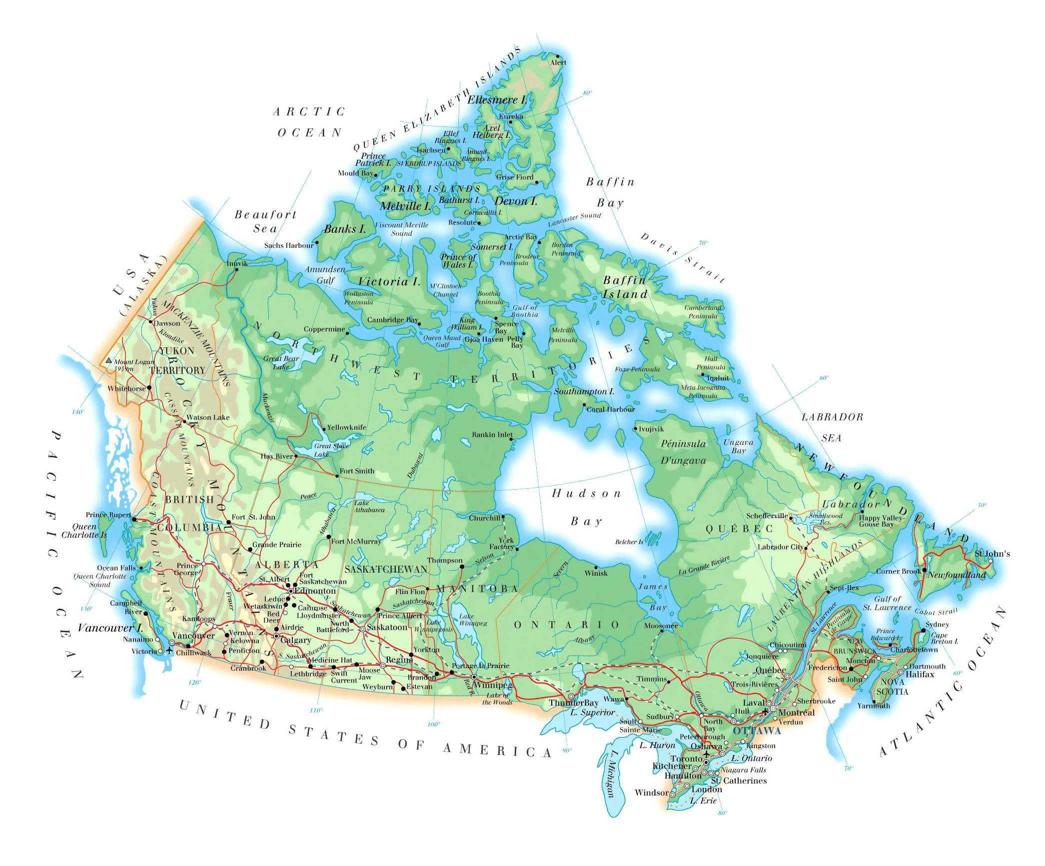
You can find on this page the Canada geographical map to print and to download in PDF. The Canada geographic map presents the topography, elevation, rivers, mountains, climate and physical features of Canada in Americas.

The Canada physical map shows landform and geography of Canada. This geographical map of Canada will allow you to discover physical features of Canada in Americas. The Canada physical map is downloadable in PDF, printable and free.
Canada physical area covers 9,984,670 km2 (3,855,103 sq. mi) and a panoply of various geoclimatic regions as its mentioned in Canada physical map. There are 8 main physical regions in Canada. Canada also encompasses vast maritime terrain, with the world longest coastline of 202,080 kilometres (125,570 mi).
The physical geography of Canada is widely varied. Boreal forests prevail throughout the country, ice is prominent in northerly Arctic regions and through the Rocky Mountains, and the relatively flat Canadian Prairies in the southwest facilitate productive agriculture as you can see in Canada physical map. The Great Lakes feed the St. Lawrence River (in the southeast) where lowlands host much of Canada population.
Canada physical features black-blue lakes, numerous rivers, majestic western mountains, rolling central plains, and forested eastern valleys as its shown in Canada physical map. The Canadian Shield, a hilly region of lakes and swamps, stretches across northern Canada and has some of the oldest rocks on Earth. Canada far north lies in the frozen grip of the Arctic, where ice, snow, and glaciers dominate the landscape. Few trees grow here, and farming is not practical.

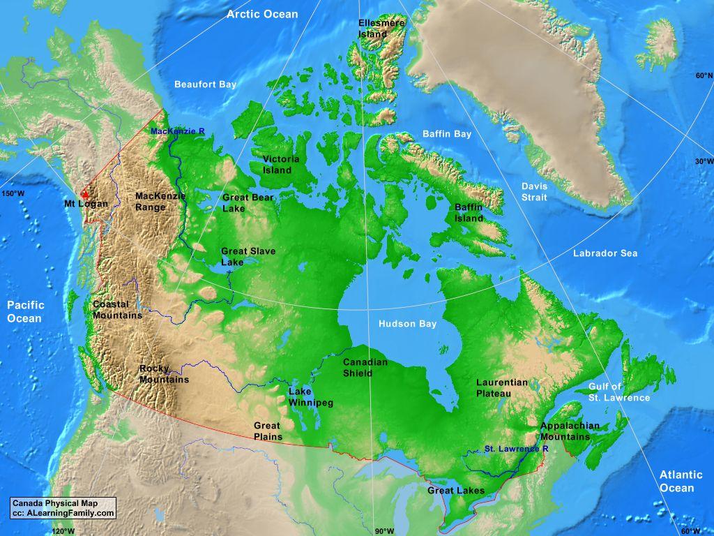
Canada topographic map shows the physical features of Canada. This topographical map of Canada will allow you to discover landforms and geographical of Canada in Americas. The Canada topographic map is downloadable in PDF, printable and free.
Canada topography is dominated by the Canadian Shield, an ice-scoured area of Precambrian rocks surrounding Hudson Bay and covering half the country. This vast region, with its store of forests, waterpower, and mineral resources, is being increasingly developed. East of the Shield as its mentioned in Canada topographic map is the maritime area, separated from the rest of Canada by low mountain ranges pierced by plains and river valleys, and including the island of Newfoundland and Prince Edward Island.
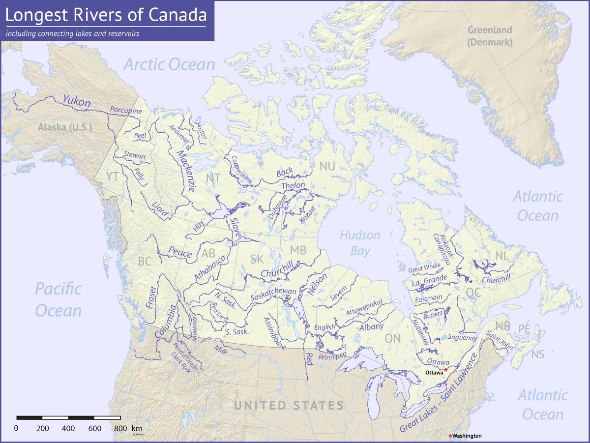
The central Canadian Shield area is drained by the Nelson-Saskatchewan, Churchill, Severn, and Albany rivers flowing into Hudson Bay. The 4,241-km (2,635-mi) Mackenzie River as you can see in Canada topographic map—with its tributaries and three large lakes (Great Bear, Great Slave, and Athabasca)—drains a topographic area of almost 2.6 million sq km (1 million sq mi) into the Arctic Ocean.
The Canadian Shield constitutes the largest mass of exposed Precambrian rock on the face of Earth. Encyclopædia Britannica, Inc. The resulting topographic surface consists of rocky, ice-smoothed hills with an average relief of 30 metres (100 feetas you can see in Canada topographic map), together with irregular basins, which are mostly filled by lakes or swamps.
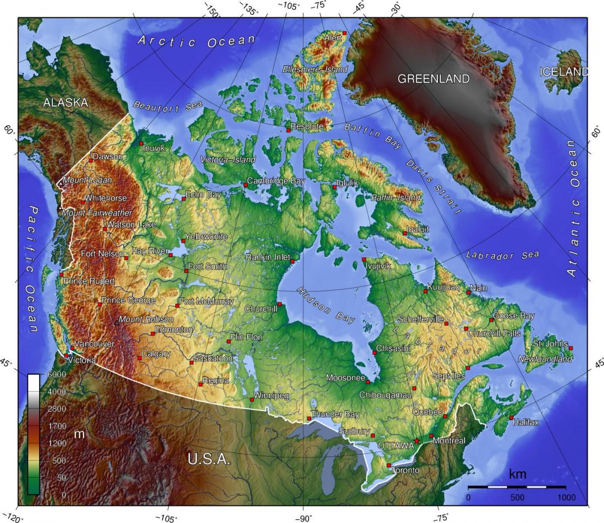
The Canada elevation map shows the different altitudes of Canada. This altitude map of Canada will allow you to know where are the highest and lowest regions of Canada in Americas. The Canada elevation map is downloadable in PDF, printable and free.
Average elevation in Canada is about 224 m which coordinates: 41.67656 -141.00275 83.33621 -52.32320 as its mentioned in Canada elevation map. The lowest elevation point is sea level at 0 m, whilst the highest point is Mount Logan at 5,959 m / 19,550 ft. Lake Louise, Alberta, is the highest town with an elevation of 1,661 m (5,449 ft).
Since there is no land area of Canada that is below sea level, the lowest elevation of Canada is at any point along its maritime coast, and all provinces and territories except Alberta and Saskatchewan have a maritime coast (see Canada elevation map). The shore of Lake Athabasca, which straddles Alberta and Saskatchewan, is Saskatchewan lowest dry point (213 m (699 ft) above sea level). The Slave River (which drains Lake Athabasca) flows from Northeastern Alberta into the Northwest Territories and is Alberta lowest point at the N.W.T. border (152 m (499 ft) above sea level). However, the False Creek Tunnel, part of the Canada Line rail-based transit system in Vancouver, at 29 metres below sea level, is the lowest publicly accessible point in Canada.
Mount Logan is the highest mountain in Canada and the second-highest elevation peak in North America, after Mount McKinley (Denali). The mountain was named after Sir William Edmond Logan, a Canadian geologist and founder of the Geological Survey of Canada (GSC). Mount Logan is located within Kluane National Park and Reserve in southwestern Yukon and is the source of the Hubbard and Logan Glaciers as you can see in Canada elevation map. Logan is believed to have the largest base circumference of any non-volcanic mountain on Earth (a large number of shield volcanoes are much larger in size and mass), with the massif containing eleven peaks over 5,000 metres (16,400 ft).
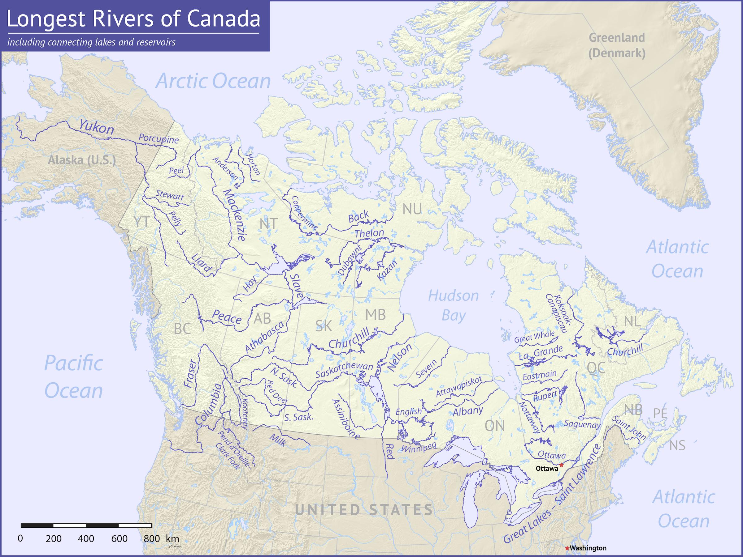
The rivers in Canada map shows the principal rivers with their names of Canada. The rivers map of Canada will allow you to find the main rivers which flow in and through Canada in Americas. The Canada rivers map is downloadable in PDF, printable and free.
Canada two greatest rivers are the St. Lawrence, which drains the Great Lakes and empties into the Gulf of St. Lawrence, and the Mackenzie, which empties into the Arctic Ocean and drains a large part of northwestern Canada as its mentioned in Canada rivers map. While the St. Lawrence is the largest river in Canada in volume of water discharged at its mouth, the Mackenzie is the longest.
Canada contains more lakes and inland waters than any other country in the world. Through the Mackenzie tributary, the Peace River, tracing to its source in the Finlay River of British Columbia, the Mackenzie is 4,241 km (2,635 mi) long and is one of the longest rivers in the world as its shown in Canada rivers map. The St. Lawrence and the Mackenzie are the second and third largest rivers by volume of discharge, respectively, in North America.
Among the great rivers of Canada as you can see in Canada rivers map are the St Lawrence, draining the Great Lakes, and emptying into the Gulf of St Lawrence; the Ottawa and the Saguenay, the principal tributaries of the St Lawrence; the Saint John, emptying into the Bay of Fundy, between Nova Scotia and New Brunswick; the Saskatchewan, flowing into Lake Winnipeg, and the Nelson, flowing from this lake into Hudson Bay; the system formed by the Athabasca, Peace, Slave, and Mackenzie rivers, emptying into the Arctic Ocean; the upper course of the Yukon, flowing across Alaska into the Bering Sea; and the Fraser and the upper course of the Columbia, emptying into the Pacific Ocean.
The mountains in Canada map shows the principal mountains with their names in Canada. The mountains map of Canada will allow you to find the main mountains ranges and highest mountains of Canada in Americas. The Canada mountains map is downloadable in PDF, printable and free.
The vast majority of mountains in Canada lie in the western provinces of British Columbia and Alberta and the Yukon Territory. Mountains can be found all over British Columbia while those in Alberta are mainly concentrated on the eastern side of the Canadian Rockies as its shown in Canada mountains map. The Saint Elias Mountains in the Yukon hold some of country highest mountains, including the highest, Mount Logan at 5,959 metres.
The Appalachian mountains (more specifically the Notre Dame and Long Range Mountains) are an old and eroded range of mountains, approximately 380 million years in age. Notable mountains in the Appalachians include Mount Jacques-Cartier (Quebec, 1,268 m/4,160 ft and Mount Carleton (New Brunswick, 817 m/2,680 ft as its mentioned in Canada mountains map). Parts of the Appalachians are home to a rich endemic flora and fauna and are considered to have been nunataks during the last glaciation era.
There are 21,324 named mountains in Canada as you can see in Canada mountains map. The highest and the most prominent mountain is Mount Logan, which is found in the St. Elias Mountains. The Appalachian mountain range extends from Georgia in the southern United States through the Gaspé Peninsula and the Atlantic Provinces, creating rolling hills indented by river valleys. It also runs through parts of southern Quebec.

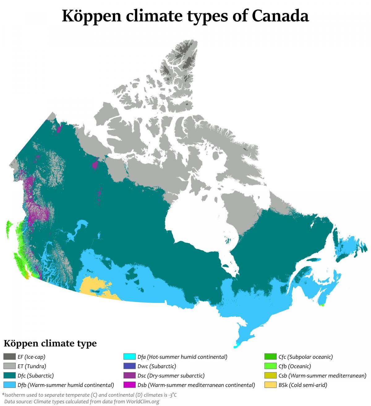
The Canada climate map shows average temperature and climate zones of Canada. This climate map of Canada will allow you to know weather, average precipitation, average sunshine and different climates of Canada in Americas. The Canada climate map is downloadable in PDF, printable and free.
Canada is often associated with cold weather and snow, but in reality, its climate is as diverse as its landscape. Generally, Canadians enjoy four very distinct seasons, particularly in the more populated regions along the US border. Daytime summer temperatures can rise to 35°C and higher, while lows of -25°C are not uncommon in winter as its shown in Canada climate map. More moderate temperatures are the norm in spring and fall.
Average winter and summer high temperatures across Canada vary from region to region. Winters can be harsh in many parts of the country, particularly in the interior and Prairie provinces, which experience a continental climate, where daily average temperatures are near −15 °C (5 °F), but can drop below −40 °C (−40 °F) with severe wind chills as you can see in as its shown in Canada climate map. In noncoastal regions, snow can cover the ground for almost six months of the year, while in parts of the north snow can persist year-round.
Coastal British Columbia has a temperate climate, with a mild and rainy winter. On the east and west coasts, average high temperatures are generally in the low 20s °C (70s °F), while between the coasts, the average summer high temperature ranges from 25 to 30 °C (77 to 86 °F), with temperatures in some interior locations occasionally exceeding 40 °C (104 °F) as its shown in as its shown in Canada climate map.